Bkksitedotcom1H.jpg (19067 bytes)

KohSamui3_A.jpg (6545 bytes)
Surat Thani Province

Back to :  www.bangkoksite.com
.


 View from the view point of Marine National Park.
Marine National Park

View from the view point.

 Chaweng Beach

 Lamai Beach.

 
 Koh Tao1
 
Welcome 
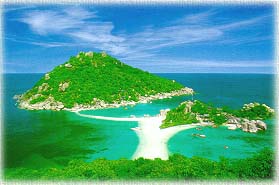
to Koh Samui and Neighbouring Islands.
Koh Samui is Thailand's third largest island, located about
496 km.(308 miles) south of Bangkok, and it belongs to Surat
Thani Province. Koh Samui has been developed into a very
popular holiday resort in South East Asia. Tourists and visitors
can really enjoy the natural beauty and spend a great holidays
there.


Super Large Video - Slideshow :
 
HQ 8,615 | SQ 4,923  kB

.Slideshow of Samui

The Big Buddha
Chaweng Beach
Lamai Beach
Elephant Trekking

Marine National Park

Restaurants (43)
Samui Pictures Collection
How to Get There :
By Air
By Train/Bus
By Ferry

1. Chaweng Beach
    9 31' 23.56" N, 100 03' 30.87" E
2. The Big Buddha
    9 34' 05.63" N, 100 03' 32.98" E

Copy and paste in Google Earth
to find out!.
Download Google Earth
----------------------------------

Samui Hotels Booking
Hotel Information and Booking
(102 Hotels)
Hotel Map & Locations
Chaweng | Lamai
Bo Phut / Choeng Mon
Mae Nam
Nathon / Taling Ngam
.

Click for Thailand Map

Maps
Koh Samui

Samui &
Nearby Islands


Click above for 5-Day Forecast

Koh Samui Google Map

View Samui Island in a larger map


   Hit Counter
Since : August 18, 1999
    Latest Update : March 28, 2012