China Town
Back to Main
Places to See (39)
Inside Bangkok
|
|
China Town |
Back to Main Places to See (39) Inside Bangkok |
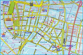
China Town Area - Yaowarat Road |
|
Location Map GPS : 13.7402796,100.5097677  Chinatown of Bangkok was former meant the area called "Sampeng", started when the Chinese merchants moved in 1780s after vacating the land where the Grand Palace now stands. In 1863, King Mongkut commanded the construction of New Road (or Charoen Krung Road) which runs over six kilometers from the Royal Palace till it drops straight into the Chao Phraya River, just south of Krung Thep Bridge now.The Chinatown expanded along Charoen Krung, Krung Kasem and the third road, the Yaowarat Road which was built between Charoen Krung and Sampeng. The China Town starts from the symbolic China Gate and follows mainly Yaowarat Road. A lot of gold shops, Chinese foods, eating places, restaurants, souvenirs, etc. are available along the long road and in several allays. It is almost unbelievable, unless you see them by yourself.
|
Chinese Restaurant - |